
MHRD-IIT Bombay has designed the latest version 5 of the map which includes metro and monorail routes besides those of the suburban railway. This initiative was headed by associate professor Mandar Rane and the transit map is at par with global standards. The maps are multi-format — foldable for pockets, PDF, and imagery in three Indian languages on the lines of the London transit map.
The wait of the commuters of Mumbai for the much-needed relief came to an end with the launch of metro line in the city. The Mumbai metro service was launched in the city on 8 June 2014, around 10:10 in the morning. It was flagged off by the Chief Minister of Maharashtra Prithviraj Chavan at the Versova station. Some of the mass transit corridors which are shown in the map that have already been thrown open and others, which have been proposed, are listed below:
- Versova – Andheri & – Ghatkopar
- Colaba – Bandra &- Charkop
- Bandra – Kurla &- Mankhurd
- Ghatkopar &- Mulund
- Charkop &- Dahisar
- Andheri(E) – Dahisar(E)
- BKC – Kanjur Marg via Airport
- Hutatma Chowk &- Ghatkopar
- Sewri &- Prabhadevi
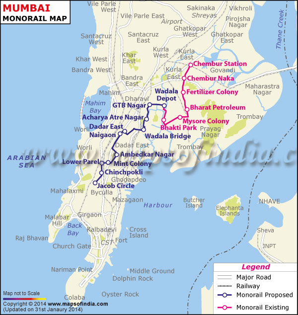
Similarly, The Mumbai Monorail opened on Sunday, 2 February 2014, as an 8.93 km stretch came into operation. It connects Wadala and Chembur in eastern Mumbai. The hours of operation are 7 a.m. to 3 p.m., with a frequency of 15 minutes. Mumbai is the first city in India to use the monorail system. And following places have been exhibited in the new map.
- Chinchpokli
- Mint Colony
- Wadala Bridge
- Acharya Atre Nagar
- Antop Hill
- GTB Nagar
- Wadala
- Bharat Petroleum
- Fertilizer Company
- Chembur Naka
The Central Railway has provided tropical support for the project and the team has now put up the maps at Dadar and Mumbai CST stations from May 9-14 to get public feedback. “Mumbai suburban railway is one of the busiest rapid transit systems in the world, operating more than 2,000 train services and carrying more than 7 million passengers every day. The need was for a well-designed transit map,” Rane said.
People suffering from color blindness will also be availed of color-coded maps. Rane said that the map size has been reduced to 7x5cms which can easily fit into a wallet when folded and can be handy for tourists.
Maharashtra government was looking for the means to better the traffic and transportation scene in Mumbai. The government wanted to come up with something that would meet the future travel needs of the commuters well. It was this exploration of idea that brought the various options of mass transit system in the picture and is very well executed in the new designed maps of Mumbai.
– By Tanvi Shah
4 Comments